Wednesday, June 1, 2016

This trip ...

For photos only, click here:
  1. Panama Canal
  2. Quito
  3. Peru
  4. Galapagos
It was time to visit a new continent - South America.  Two primary attractions: Galapagos Islands (Ecuador) and Machu Picchu (Peru.)  You could possibly add Patagonia to the list, but that would be in lieu of visiting Antarctica.

Because Dec/Jan is rainy season in Peru, we switched our 2015 winter trip to Central America (Yucatan and Costa Rica) instead.  Best time to visit Peru is July-August, but to avoid crowds, late May-early June is better.

There's never a bad time to visit Galápagos. It depends on what you want to see/experience on these islands.  From crowd standpoint, peak seasons last from mid-June through early September and from mid-December through mid-January.  Because the national park limits the number of visitors to each island and coordinates each ship's itinerary, the Galápagos will never feel like Disneyland.  But you are likely to feel a sense of solitude and isolation.  On our trip, on some islands, ours was the only boat.  At most, there were 5 boats at one location, but our landing times were different.

Late May in Galapagos and early June in Peru worked out perfectly for us.  No rains whatsoever,  Cloudy at times, but not foggy.  A bit chilly at nights and perfect 70s during days.  Because the water is warmer at this time, swimming and snorkeling are more enticing.  We didn't need wetsuits.

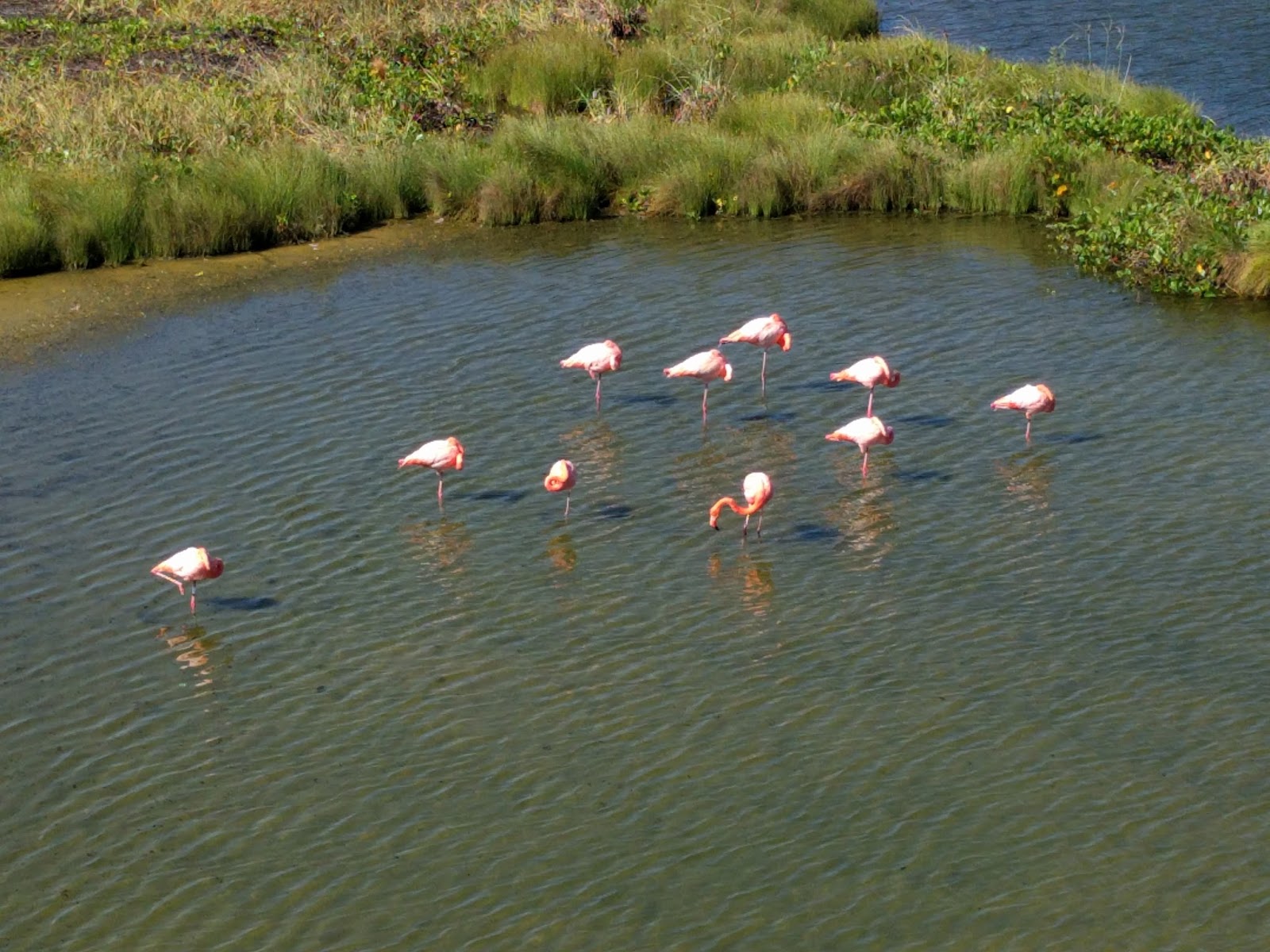
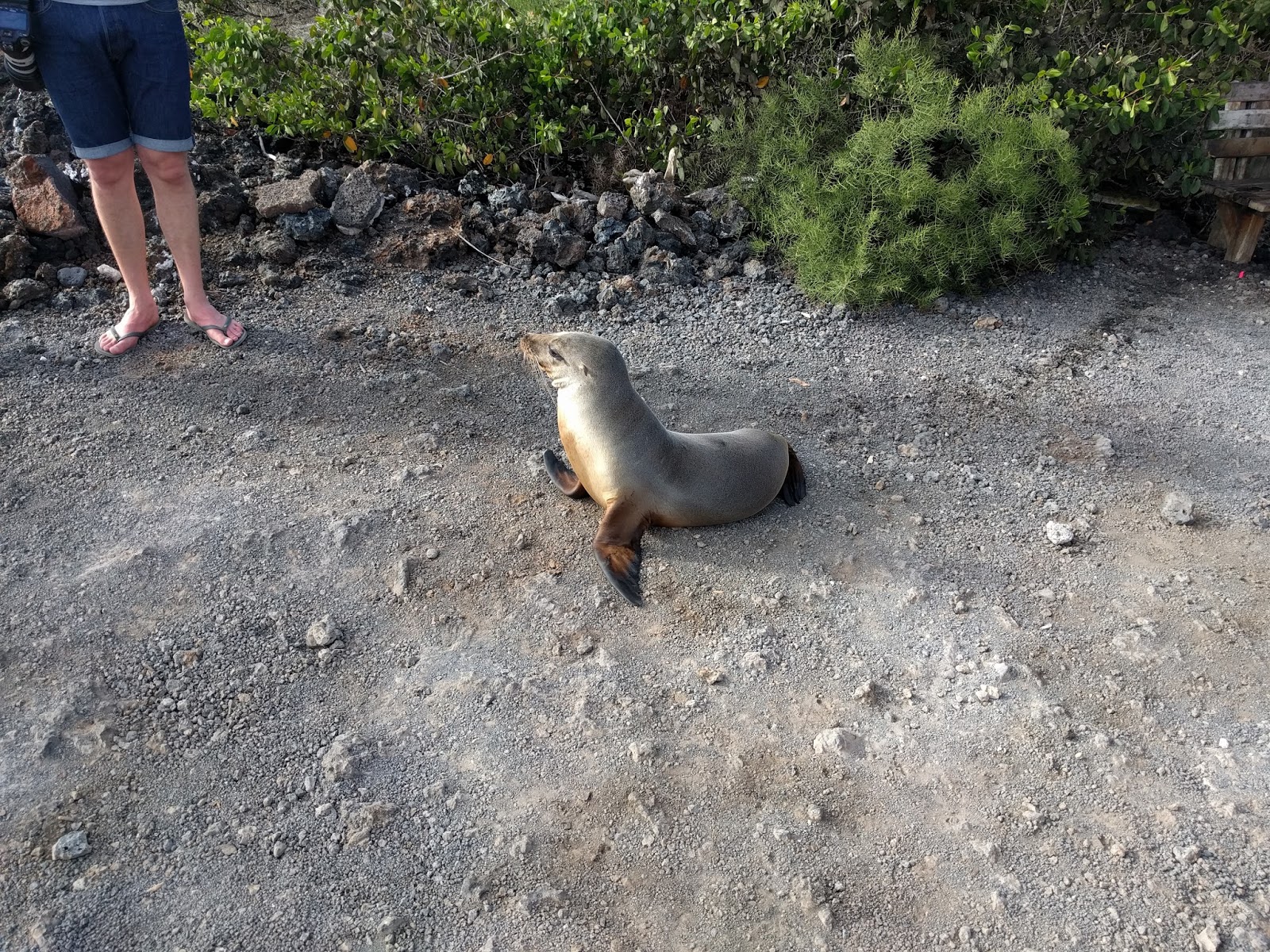
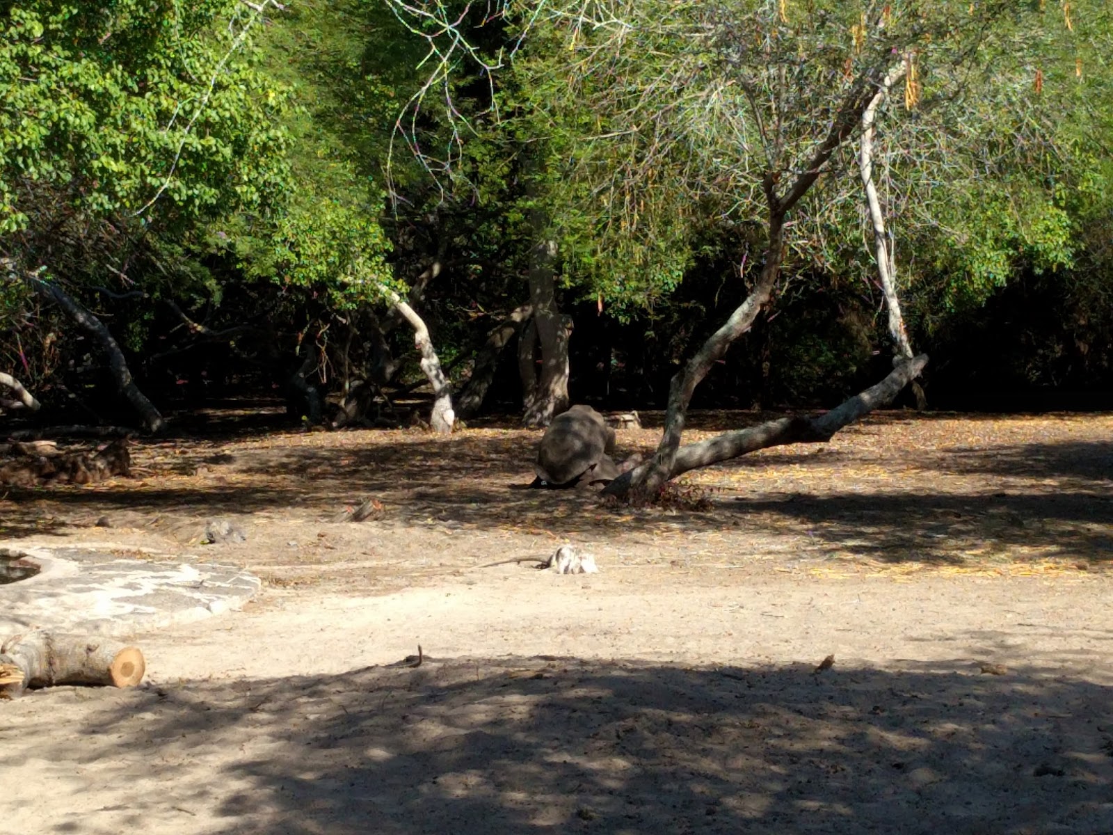
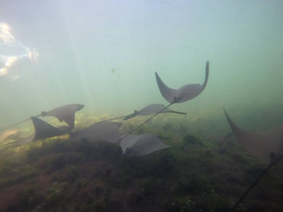
This is the breeding season for land birds in Galapagos, so it's a good time to watch some unusual mating rituals, as well as nesting - eggs and chicks being tended to.  If you're into turtles, you can watch sea turtles nesting on the beach, and see land tortoises searching for mates around the lowland areas of the islands.  You'll also see adorable newborn sea lion pups frolicking on beaches and in shallow waters.  Another benefit of traveling to the Galápagos at this time of year: The ocean is much calmer, so less chance of getting seasick.

In general, Galapagos is expensive.  For trip planning purposes, a cheaper option is to stay on one of the islands (BNB or hostels) and take day trips for sightseeing.  The islands are however fairly spread out, and you may end up spending a lot more time ferrying than sightseeing.

Cruise-tours is a better option - boat travels at night to the next island (that also means less chance of seasickness), and you are parked minutes away from the sightseeing spot for the next day.  We were on a double hulled catamaran. which by design is more stable whether parked or going full speed.  That however creates interesting room access situation, where you have to climb wooden ladder to enter/exit your room.  More on this later.

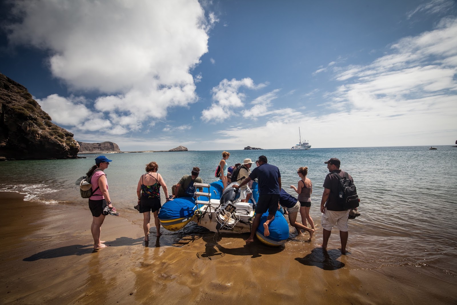
The largest cruise ship here has 60 rooms (120 people), whereas our catamaran had 7 rooms (14 people.  In actuality, we had only 11), so we could all pile up in one Zodiac inflatable boat and off we went.

Cost-wise, at high end, you could pay $1000 per day, per person for Luxury Class travel - remember, your first and last day are just arrival and departure so a 10 day cruise is really only 8 days of sightseeing.


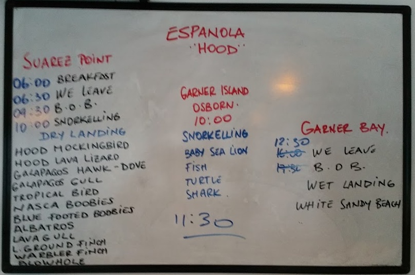
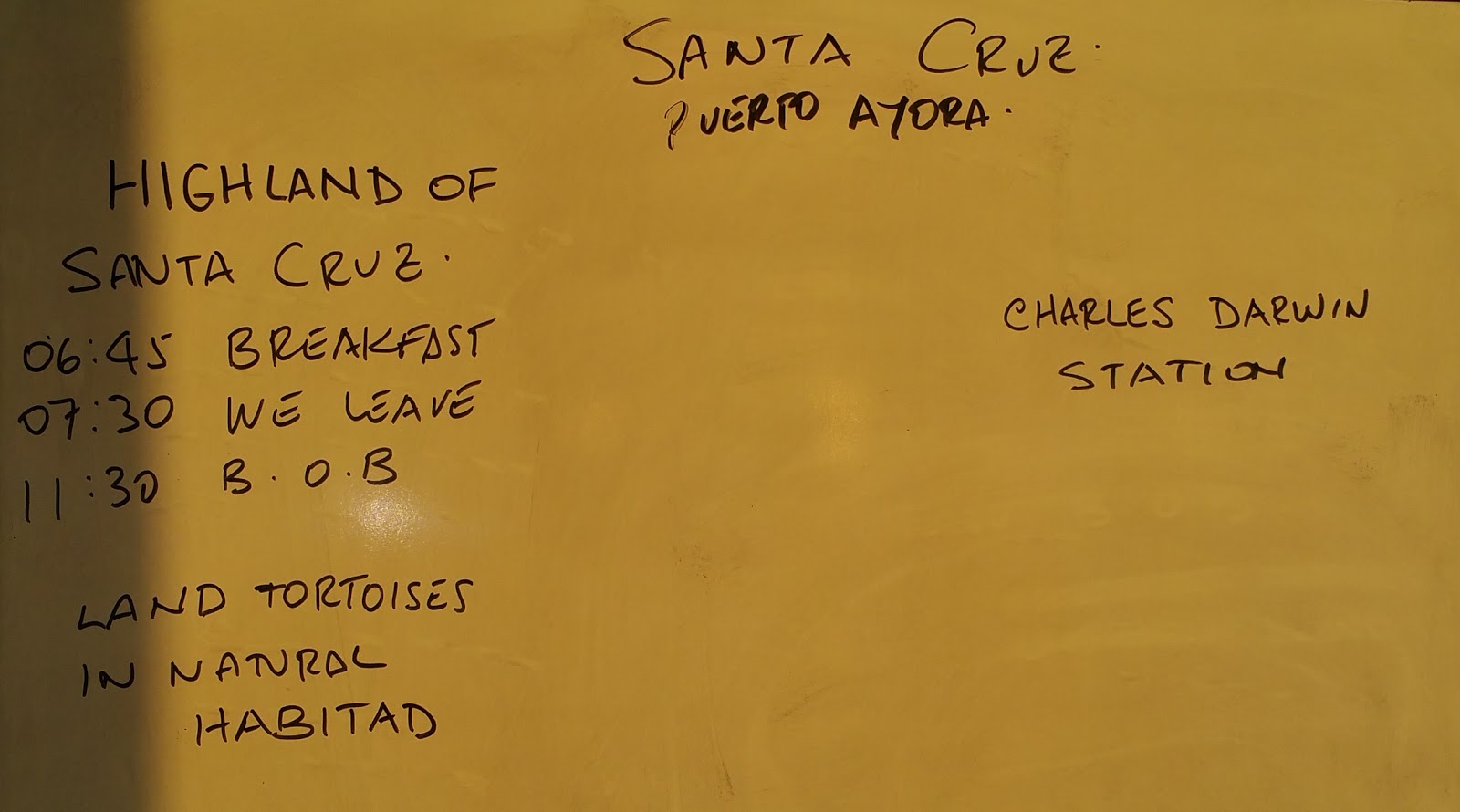
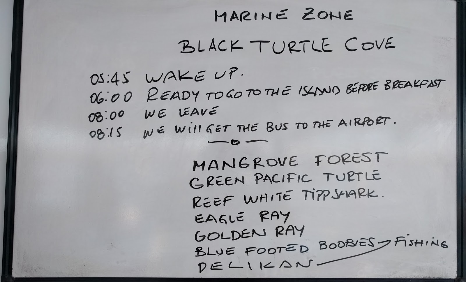
Typically, you'd have 3 two-hour activities each day - a combination of hikes and snorkeling/ swimming.  Our cruise began at Baltra (the blue route) for 5 days and continued on the red route for another 3 days.  Total 11 people started at Baltra.  Six got off after the blue route, and five new people joined for the red route.  Both groups were very happy with their own experiences.  In hindsight, there was a lot of repetition on the red route for us, so it would have been just fine if we'd stopped after the blue route as well.  But then again, we saw lot more nesting birds, with eggs and chicks, and did a lot more snorkeling on the red route.

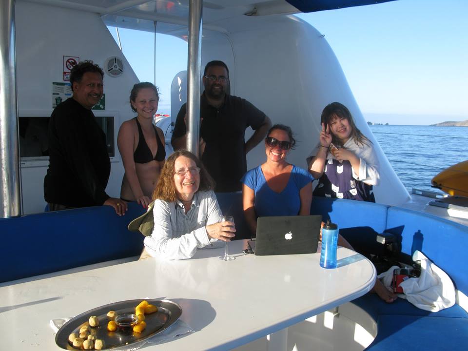
What does a typical tourist to Galapagos look like?  No surprise - over half (6 on the blue route and 7 on red) were from the US - of which, 4 were from California, the rest from the East Coast.  Others were from Europe and Canada.  A lot more younger crowd than I expected though - 10 out of total 16 in both groups were in their 30s or less - youngest being 20.  Because of the small group size, we got to know each other very well.  All meals were together - buffet style, on two tables side-by-side.  And there was plenty of deck space to lounge around as you see in photos below.


Nemo I Catamaran - double hulled
Nemo I - back deck - loading and dining area
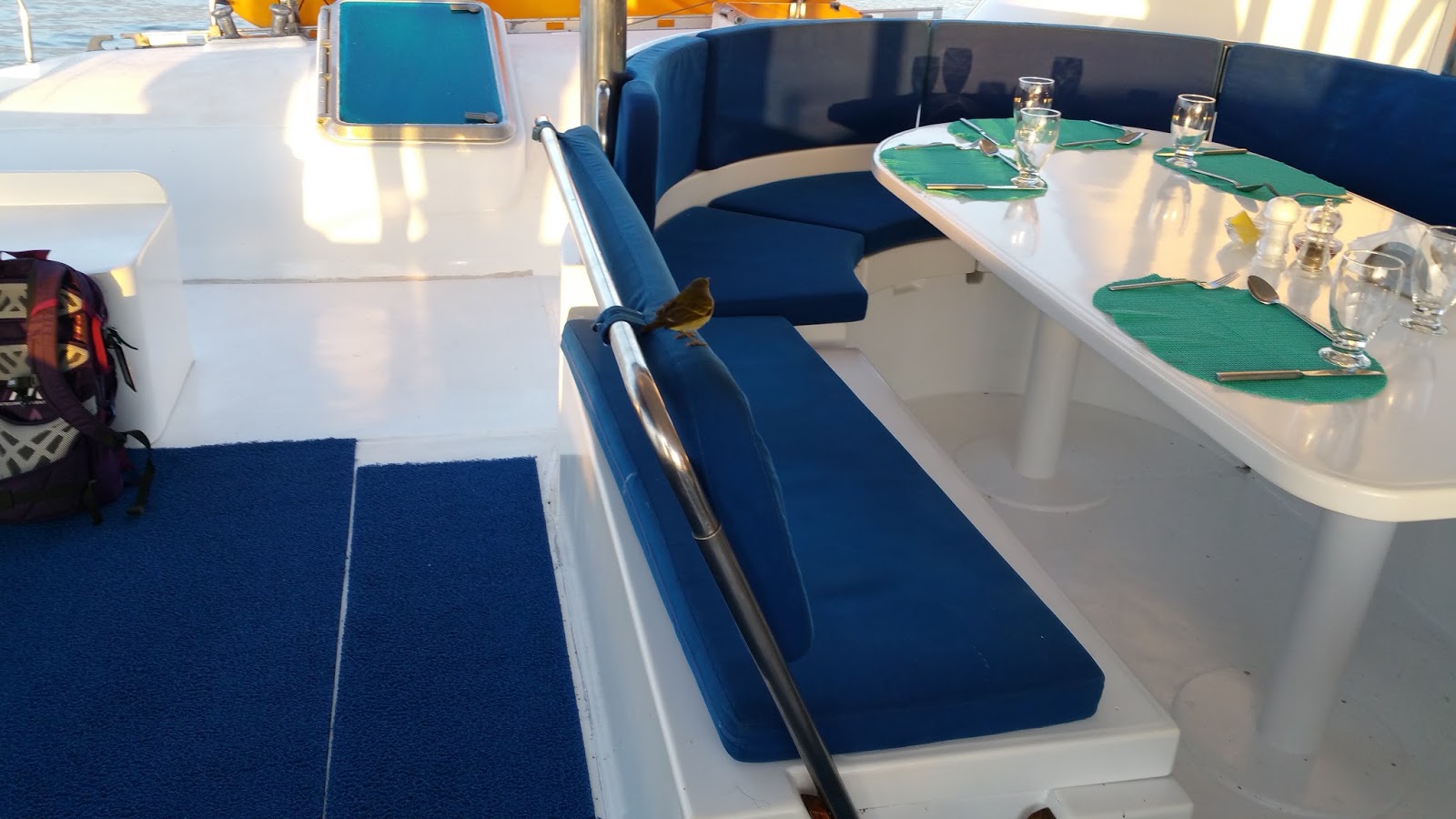
Dining


Dining and lounging area

Front Deck for sunbathing
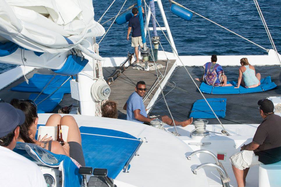

And for relaxing

Food was great, and so was the service.  You could always do more activities, but what we were able to do and experience was plenty.  Some people suffered from seasickness and/or stomach problems, but everyone was able to enjoy most of the activities just fine.

Tuesday, May 31, 2016

Panama City - visiting Panama Canal Locks

Photos

During our Jan 2015 trip to Costa Rica, I was tempted to take overnight bus to Panama City just to visit Panama Canal locks and return the next day.  It was however too much time/trouble just to check one box off my Bucket List.  All other sightseeing in Panama was covered with similar ones in Costa Rica.

Then it happened this time even without trying.  Our trip to South America, although booked through United Mileage, was almost entirely on Avianca Airlines - a Colombian airline with subsidiary in Peru and part of Star Alliance, with a connection in Panama City and a six hour layover.

Booking flights using mileage is always tricky, sometimes impossible or at a minimum, inconvenient.  While searching, I discovered that economy booking for any combination of flights required 55000 miles plus tax.  Instead, for only 15000 additional miles, I could get much better connections entirely on business class.  That made travel much simpler, elegant, and with perks.  In addition to food and drinks on flights, we could use Airline Clubs at the airports (so we thought!)

For our 1:30 am flight from SFO on Sun May 22, we took an earlier BART train and planned to wait at the United Club (which closed at midnight) before going to our gate.  At SFO, International terminal "I" consists of gates in both Terminal G (left) as well as in Terminal A (right.)  Our flight was from Gate A5, which we found out only when we reached the airport.  United Club was near Gate G94 - with no connecting corridor.  Of course, we learned this the hard way - after spending 45 minutes in TSA line to Terminal G.  Disappointed, we then cleared security for Terminal A, and waited for our flight.


Our plane blockaded by fire squad

The flight was shown ON TIME, but the plane arrived late.  Just before the boarding began, a fire truck rolled in with lights flashing accompanied by four other fire vehicles, and blockaded our plane, as you see in the picture above.


Bad omen, we thought.  We had a connecting flight to catch at San Salvador (SAL) with only 35 minute layover.  If we miss that, the rest of our plan could be in jeopardy.

The fire emergency cleared quickly, and the flight left almost on time.  Business class on this A320 plane (as well as on A319, our later flights) had 12 seats - 3 rows of four across.  Plenty of legroom, separate armrest, leather seats, drinks and food to boot.  On newer planes (A330) the seats actually converted to flat bed.  Our flight back from Lima, Peru (LIM) to SAL was on A330.  On such longer flights, these little conveniences make a lot of difference.

SAL is a small airport.  We landed at Gate 8 and our next flight was from Gate 3.  Because we could go to the gate directly (without having to clear security again), all we had to do was to run.  Along the way, a couple of airline employees were announcing the gate for our flight.  The flight was still boarding when we reached the gate, and the flight departed on time.

Panama City (PTY):

We had over 6 hours in Panama City (from 11:30 am to 6:40 PM.)  The next flight was on Panama's COPA airlines, which had a COPA club at the airport for business class passengers.  That worked out perfectly for us.  We could leave our bags there for the day, come back, have some snacks, take a shower and relax before the next flight.

The Club front desk advised us to take a taxi ($30 each way) as the most convenient way.  I however like to travel like locals.  I had checked a website (PTY.LIFE) where the writer provided detailed directions, including pictures, on how to take a bus.  "From the airport, you can take the Metro Bus directly to the Albrook bus terminal, and from there transfer to the Miraflores bus to see the canal." he advised.  He also warned that you can't buy metro card at the airport, and buses don't accept cash.  How do you then ride the bus?  (HINT: You can ask locals to swipe their card for you, and you pay them cash.)

We walked to the bus stop a quarter mile away.  It was 90 degrees, and probably 90% humidity.  Forecast was partly cloudy with a chance of thunderstorms.  It wasn't raining at that time, but we were completely soaked with sweat by the time we reached the bus stop.

Local bus (Diablo rojo) rides cost 25 cents in the city; more beyond depending on distance traveled.  Air conditioned buses cost $1.25.  You pay when you exit the bus, and the driver will make change.  Both US or Panamanian quarters work here.  For paper currency, US dollar bills is the official currency - so it is in Ecuador.

The first Albrook bus to arrive was a Metro bus.  We got on and offered our dollar bills.  The driver refused and from what I gathered, asked us to get a metro card (which we knew) or get coins (quarters, which we didn't have), and then left without us.

Frustrated, we asked a gentleman at the bus stop.  He directed us to someone who looked like a bus stop attendant, and had change for a couple of dollars.  He also advised us to be patient with bus service.

The next bus to come was a private bus going to Albrook Terminal (called just Terminal.)  We got on and paid when we got off at the Terminal ($1.25 cash.)  Private buses are being phased out - I'm glad they were still around for us.

At Albrook terminal, we purchased a 3-in-1 pass (although we used only the bus part) - $2 for the card itself, plus additional fare for the two of us.  One pass works for multiple passengers.  To purchase the pass, however, they need your name and passport number - so we couldn't give away that pass after we were done.

It started raining when we got on the bus, but stopped before we reached Terminal 45 minutes later.  It took us a while to figure out where and which card to purchase, and where to find the Miraflores bus.  The terminal is large with hundreds of buses passing through.  Bus stops have roofs so waiting for the bus wasn't too bad.  It however took a long time for our bus to show up.  It looked like a couple of buses went out of service.

In any case, I had read that only about 40 ships pass through the canal each day.  They go in one direction in the morning, and then they switch direction for the afternoon - after 2 PM.  We were therefore in no hurry to get there fast.

Finally, a bus arrived at 2 PM and took us to the Locks in 15 minutes.  It had rained intermittently for the past hour or so, but stopped again as we reached the Locks.

The bus drops you off right at the entrance where you take an escalator up, and enter the Visitor Center building after purchasing tickets.

Foreigners pay $15 for a ticket, which includes access to a few short films, a museum, and some rooms that recreate the view of engineers and ship captains during crossings.

We skipped the 10 minute film that runs nearly constantly alternating between Spanish and English about the construction and history of the canal.  And also the displays about the construction of the museum - all available by googling.  We headed straight to the observation deck a couple of levels up.  Bleachers were full, but there was plenty of standing room on the sides.

We had reached just in time.  Two small boats - one of which was a small cruise ship taking tourists across the canal - were already in, and a large cruise ship was approaching,  As you see in the photos, within an hour, we were able to see the locks in operation - bringing boats in, closing gates, lowering the water level, and opening gates to let the boats out.

By 3:30 PM, we were done.  While waiting for the bus, a taxi driver tried to convince us to take taxi back to the airport.  From $30, he came down to $25 but no further.  We had plenty of time (and bus tickets) to return to the airport; it wasn't raining; and we had figured out the public bus routine.  In exactly one hour, we were back at the airport, had time to take a shower and have some snacks before going to gate for the next flight.  It of course helped that it was a Sunday and therefore, traffic was light.  We could have, for less than $10, rented a car and driven around ourselves.

Some interesting facts about the Canal:
  • Before the Canal was built, to get around the Americas, you had to travel about 8000 miles farther to the south of South America.
  • The Canal runs north-south to link the Atlantic and Pacific Oceans, not east-west as you'd guess.
  • Some 13,500 ships transit the canal each year, almost 40 a day.  In Panama Bay, just outside the Canal, a large number of ships - big and small - await their turn to enter the Canal.
  • The Panama Canal has six locks, three near either end.
    - From the Pacific Ocean, near Panama City, the Miraflores Locks' two chambers each raise vessels 27 feet. A short distance away, the Pedro Miguel Lock lifts ships a further 31 feet.
    - Most of the passage through the canal is at 85 feet above sea level.
  • The locks are gravity fed from the Chagres and Gatun Lake. No pumps are needed. Water pours through a huge culvert in the center wall of each lock. Other large culverts pass through the side walls. Water fills or empties through vents along the bottom of the locks, 26 million gallons in just eight minutes.
  • The two oceans have different sea levels, and different levels of high tide.  At the entrance to the Panama Canal, the Pacific Ocean can rise as much as 20 feet, but 45 miles away, the difference between high tide and low in the Atlantic is just three feet.
  • The U.S. had a licensing agreement in perpetuity to operate the Canal, but in 1977, President Carter signed an agreement to hand over the Canal to Panama effective 1999.  Even now, the U.S. is responsible for safeguarding the Canal.  Most U.S. Naval vessels, except aircraft carriers, can pass through the current Canal.
  • Expanded canal, doubling its capacity, is expected to open shortly.

Tuesday, May 24, 2016

Galapagos - history and geography

The Galápagos Islands (Islas Galápagos) are an archipelago of volcanic islands near the Equator in the Pacific Ocean, 563 miles west of continental Ecuador.  The Islands and their surrounding waters form the Galápagos Province of Ecuador, the Galápagos National Park, and the Galápagos Marine Reserve.

Formed from volcanic activity, which continues today, the islands are isolated from other land masses and developed their own ecology from the flora and fauna that was brought here by wind, water, oceanic animals and humans.  Now famed for their vast number of endemic species - first studied by Charles Darwin during the voyage of the Beagle, which contributed to Darwin's theory of evolution by natural selection.

Galápagos or Tortoises, in case you wondered, dwell on land, whereas Turtles live in the water some or nearly all of the time.

Some history: 

The first recorded visit to the islands happened by chance in 1535, when the Bishop of Panamá Fray Tomás de Berlanga was blown off course.  He eventually returned to the Spanish Empire and described the conditions of the islands and the animals that inhabited them.  The first crude map of the islands was made in 1684 by the buccaneer Ambrose Cowley, who named the individual islands after some of his fellow pirates or after British royalty and noblemen.  The new Republic of Ecuador took the islands from Spanish ownership in 1832, and subsequently gave them official Spanish names.  The older names remained in use in English language publications.

Some Geography: 

The islands are found at the coordinates 1°40'N–1°36'S, 89°16'–92°01'W. - straddling the equator, with Volcán Wolf and Volcán Ecuador on Isla Isabela being directly on the Equator.  Volcán Wolf is the highest point, with an elevation of 5,600 ft above sea level.

Depending on who is counting, the group consists of 18 main islands (each having a land area of at least 1 sq km), 3 smaller islands, and 107 rocks and islets.  The archipelago is located on the Nazca Plate (a tectonic plate, which is moving east/southeast), diving under the South American Plate at a rate of about 2.5 inches per year.  It is also atop the Galápagos hotspot, a place where the Earth's crust is being melted from below by a mantle plume, creating volcanoes.

While the older islands have disappeared below the sea as they moved away from the hotspot, the youngest islands, Isabela and Fernandina, are still being formed on the west side.

Of the main islands of the archipelago, we visited the following (alphabetical):
  • Baltra Island – Also known as South Seymour, Baltra is a small flat island located near the center of Galápagos.  It was created by geological uplift. The island is very arid, and vegetation consists of salt bushes, prickly pear cacti and palo santo trees.
    - Until 1986, Baltra was the only airport serving the Galápagos. Now, there are two - the other one being San Cristóbal, the capital.  Private planes must fly to Baltra, as it is the only airport with facilities for planes overnight.
    - Baltra Airport was recently renovated to accommodate larger planes such as Boeing 737s.  There is however only one runway - the plane lands from the right, stops at the other end of the runway, turns around and returns all the way back to the terminal for unloading and reloading.


    - Up on arriving in Baltra, visitors are immediately transported by bus to one of two docks. The first dock is located in a small bay, where the boats cruising Galápagos await passengers. The second is a ferry dock, which connects Baltra to the island of Santa Cruz.
    - During the 1940s, scientists decided to move 70 of Baltra's land iguanas to the neighboring North Seymour Island as part of an experiment.  This move proved unexpectedly useful when the native iguanas became extinct on Baltra as a result of the island's military occupation in World War II.  During the 1980s, iguanas from North Seymour were brought to the Charles Darwin Research Station as part of a breeding and repopulation project, and in the 1990s, land iguanas were reintroduced to Baltra.
    Photos:
    -- Santa Cruz (Baltra GPS)
    -- Santa Cruz (Puerto Ayora)
    -- Santa Cruz (Black Turtle Cove)
  • Española IslandNamed in honor of Spain, it also is known as Hood, after Viscount Samuel Hood.  It has an area of 23 sq mi, and a maximum altitude of 676 ft.  Española is the oldest island at around 3.5 million years, and the southernmost in the group.
    - Due to its remote location, Española has a large number of endemic species. It has its own species of lava lizard, mockingbird and tortoise.  Española's marine iguanas exhibit a distinctive red coloration change between the breeding season.  Española is the only place where the waved albatross nests.  Española's steep cliffs serve as perfect runways for these birds, which take off for their ocean feeding grounds near the mainland of Ecuador and Peru.  This island has two visitor sites:
    - Gardner Bay is a swimming and snorkeling site, and offers a great beach.
    - Punta Suarez has migrant, resident, and endemic wildlife, including brightly colored marine iguanas, Española lava lizards, hood mockingbirds, swallow-tailed gulls, blue-footed boobies, Nazca boobies, red-billed tropicbirds, Galápagos hawks, three species of Darwin's finches, and the waved albatross.
  • Floreana (Charles or Santa María) Island It was named after Juan José Flores, the first President of Ecuador, during whose administration the government of Ecuador took possession of the archipelago.  It is also called Santa Maria after one of the caravels of Columbus.  It has an area of 67 sq mi, and a maximum elevation of 2100 ft.
    - It is one of the islands with the most interesting human history, and one of the earliest to be inhabited. Flamingos and green sea turtles nest (December to May) on this island. The patapegada or Galápagos petrel, a sea bird which spends most of its life away from land, is found here.
    - At Post Office Bay, where 19th century whalers kept a wooden barrel that served as a post office, mail could be picked up and delivered to its destinations, mainly Europe and the United States, by ships on their way home.
    - At the "Devil's Crown", an underwater volcanic cone and coral formations are found.  Snorkeling here was a fun challenge.
  • Isabela (Albemarle) Island This island was named in honor of Queen Isabela.  With an area of 1,792 sq mi, it is the largest island of the Galápagos.  Its highest point is Volcán Wolf, with an altitude of 5600 ft.  The island's seahorse shape is due to the merging of six large volcanoes into a single land mass.
    - On this island, Galápagos penguins, flightless cormorants, marine iguanas, pelicans and Sally Lightfoot crabs abound.  At the skirts and calderas of the volcanoes of Isabela, land iguanas and Galápagos tortoises can be observed, as well as Darwin finches, Galápagos hawks and Galápagos doves.  The third-largest human settlement of the archipelago, Puerto Villamil, is located at the southeastern tip of the island.
    - It is the only island to have the equator run across it.  It is also the only place in the world where a penguin can be seen in its natural habitat in the Northern Hemisphere.
    - Sierra Negra Volcano is active and its toxic (Sulfur) environment is killing a subspecies of tortoises found only around this volcano.  To protect them from extinction, Government has moved all adults in to "ARNALDO TUPIZA" Breeding Center where they are now bred in captivity.  If natural selection is allowed to prevail, shouldn't tortoises endemic to this area either adapt to the toxic environment, or move away to survive - without human interference?
  • San Cristóbal (Chatham) Island It bears the name of the patron saint of seafarers, "St. Christopher".  Its English name was given after William Pitt, 1st Earl of Chatham. It has an area of 215 sq mi, and its highest point rises to 2395 ft.
    - This is the first island in the Galápagos Archipelago Charles Darwin visited during his voyage on the Beagle. This island hosts frigate birds, sea lions, giant tortoises, blue- and red-footed boobies, tropicbirds, marine iguanas, dolphins and swallow-tailed gulls. Its vegetation includes Calandrinia galapagos, Lecocarpus darwinii, and trees such as Lignum vitae. The largest freshwater lake in the archipelago, Laguna El Junco, is located in the highlands of San Cristóbal. The capital of the province of Galápagos, Puerto Baquerizo Moreno, lies at the southern tip of the island.  Cliff Kicker Rock off the island - on west side, is a great spot for diving.
  • Santa Cruz (Indefatigable) Island Given the name of the Holy Cross in Spanish, its English name derives from the British vessel HMS Indefatigable. It has an area of 381 sq mi, and a maximum altitude of 2834 ft.
    - Santa Cruz hosts the largest human population in the archipelago, the town of Puerto Ayora.  The Charles Darwin Research Station (CDRS) and the headquarters of the Galápagos National Park Service (GNPS) are located here.  CDRS and GNPS operate a tortoise breeding center (similar to the one on Isabela), where young tortoises are hatched, reared, and prepared to be reintroduced to their natural habitat. The Highlands of Santa Cruz offer exuberant flora, and are famous for the lava tunnels.  Large tortoise populations are found here.
    - Black Turtle Cove is a site surrounded by mangroves, which sea turtles, rays and small sharks sometimes use as a mating area.  Cerro Dragón, known for its flamingo lagoon, is also located here, and along the trail one may see land iguanas foraging.
    - Isla Plaza Sur (South Plaza Island) also has cactus forests as well as colorful flora - mainly ice plants, and large bird population to observe.
      - Smooth-billed Ani is an introduced species of black birds that deparisitize livestock, but they soon found liking towards tortoise eggs.  As a result, during vacations, high school students are encouraged to kill these birds using sling shots, and are rewarded $20 per head.  So much for survival of the fittest!
  • Santa Fe (Barrington) Island Named after a city in Spain, it has an area of 9 sq mi, and a maximum altitude of 850 ft.
    - Santa Fe hosts a forest of Opuntia cactus, which are the largest of the archipelago, and Palo Santo.  Weathered cliffs provide a haven for swallow-tailed gulls, red-billed tropic birds and shear-waters petrels. Santa Fe species of land iguanas are often seen, as well as lava lizards.
    - Santa Fe also has sea lion harems on one side of the island, whereas the "losers" stay on the other side to rest and gain strength for the next mating season.
Although located on the Equator, the Humboldt Current brings cold water to these islands from Antarctica, causing drizzles any time of the year. The weather is periodically influenced by El Niño, which occurs every 3–7 years and is characterized by warm sea surface temperatures, a rise in sea level, greater wave action, and a depletion of nutrients in the water.  All part of natural cycle observed all around the world, and for sure, not "Climate Change" phenomenon as people would like you to believe.

Normally, during the garúa season (June to November), the temperature by the sea is cooler 72 °F, a steady and cold wind blows from south and southeast, frequent drizzles (garúas) last most of the day, and dense fog conceals the islands.  During the warm season (December to May), the average sea and air temperature rises to 77 °F, there is no wind at all, there are sporadic, though strong, rains and the sun shines.

There are about 85 yachts and ships equipped for overnight guests. In Baltra, limited overnight camping is permitted.  Other inhabited islands also allow camping on the beaches designated as "recreational" use to the locals.  All of these camping permits are limited to number of people and nights - not to exceed three.

Land based hotels are opening on the inhabited islands of San Cristobal, Santa Cruz, Floreana and Isabela.  More than half the visitors to Galápagos make their tours using day boats and these small hotels.  Restaurants, easy access and economy make this an attractive travel option.  As noted earlier, cruise tours are still the best way to see all the complex environment and wildlife of the islands.

There are only 116 visitor sites in the Galápagos: 54 land sites and 62 scuba-diving or snorkeling sites. Small groups are allowed to visit in 2- to 4-hour shifts only, to limit impact on the area.  All groups must be accompanied by licensed guides.

Food for thought:
  • Galapagos needs $125 million just to maintain the ecosystem of the islands.  Where should that money come from?
    - Ecuador can use its own oil money, but that may be best spent to improve the quality of life for its citizens first.
    - Best way to raise money otherwise would be to sell something (some of its islands for commercial development, or its wildlife), or to permit more tourism without tipping the balance.  
  • After years of debating, planning and consensus-building, the Galapagos Conservancy (formerly called the Charles Darwin Foundation) initiated Project Isabela, a systemic eradication of all of the goats, feral pigs and donkeys on the main Galapagos islands. -- see http://www.galapagos.org/conservation/conservation/conservationchallenges/invasive-species/  Dogs were also supposedly eradicated, but we saw a few on Santa Cruz island.  Survival of the fittest?
Sample of wildlife you'd expect to see in the Galapagos: https://goo.gl/photos/2pU3y7Bqdy2PspRU9

Flamingo mating dance


Mangroves - life finds a way

Penguin fishing
Sea lion pup - not backing off

Second smallest penguins - only ones at the Equator


White tipped sharks

Mating turtles


Cruise-tour of Galapagos - details and photos

Picking a package for Galapagos turned out to be a challenge - until you know: How many islands to visit?  Which ones - North or South?  What to see on each?   When?  How do you travel between islands?  Where to stay - land based vs cruise-tours?  How many days are enough?  What time of the year?  And of course, the cost?

The itineraries and prices vary wildly - from one package to another -- even within one travel company, it was very much apples and oranges.  And they were rushing us to sign up early - in January, or risk being sold out.  (Last minute deals are still available for significant savings at http://galapagosinformation.com/galapagos-cruises-last-minute.html)

Only after we started narrowing down our options based on what we wanted to see (for example, Albatross are only on Espanola), comparing cruises became a lot easier.  In the end, we signed up with http://www.southernexplorations.com/galapagos-island-cruises/nemo-i - itinerary B on Nemo I Catamaran for South Islands for 10 days/9 nights, starting either in Quito (capital) or Guayaquil (largest city), depending on our connecting international flights.

As we later found out, there are only a limited number of cruise ships allowed to operate in the Galapagos.  Those cruise operators prefer that tourists sign up through travel agencies such as Southern Explorations, instead of signing up directly with them.  So all travel agencies are merely intermediaries competing for the same tourists on the same cruises.  We were the only ones on Nemo I signed up through Southern Explorations.  Rest came through other agencies - and probably paid different prices.


Typical itinerary

You arrive at Quito/Guayaquil on Day 1 (Sun) and leave on Day 10 (Tue.)  On Day 2 (Mon), you fly to Galapagos to begin the cruise-tour, spend 8 days and fly back on Day 9 (Mon.), as follows:


MONDAY
Daily activity was detailed on the white board for everyone's reference
Bachas Beach, Santa Cruz – These two small beaches are found to the west of Turtle Cove. The sand is made of decomposed coral, making it white and soft, and thus a favorite nesting site for sea turtles. Behind one of the beaches is a small brackish lagoon, where it is possible to observe flamingos and other coastal birds, such as black-necked stilts and whimbrels. On the other beach are two barges that were abandoned during World War II when the U.S. used Baltra Island as a strategic point to protect the Panama Canal.  Afterwards, we snorkeled at that beach - just getting our feet wet, so to speak.  We did see a giant turtle and many fish - small and large.

TUESDAY

Tintoreras & Tortoise Breeding Center, Isabela - Today’s first excursion is a hike followed by snorkeling at Tintoreras, a group of tiny islands off the coast of the town of Puerto Villamil on Isabela Island. White-tipped reef sharks (or “Tintoreras”) are common in the shallow waters surrounding these islands, and you may encounter eagle rays, sea turtles, and perhaps even penguins.  This is a great snorkeling spot as well as a fantastic place to view marine iguanas.

In the afternoon, we visited La Galapaguera, a breeding center with interpretative trails where giant tortoises can be viewed in captivity.  Walking to the Galapaguera center, you will pass over a boardwalk through a brackish lagoon for a view of flamingos.

WEDNESDAY


Punta Cormorant & Devil’s Crown, Floreana – Punta Cormorant, located on the northern shore of Floreana, offers a large salt lagoon, situated between two volcanic tuff cones, where flamingos nest. You may also observe other aquatic birds including black-necked stilts and white-cheeked pintail ducks. On this visit, you will see the two distinct beaches: “Green Beach,” named for the presence of the mineral olivine in the sand here, and “Flour Sand Beach,” made of finely ground coral.


Devil's Crown
Just off Punta Cormorant lies Devil’s Crown, which offers excellent snorkeling. In fact, the only way to see the Crown is by water; it is termed a Marine Visitor Site and no landings are allowed. This site is an almost completely submerged volcanic crater, and erosion has transformed the cone into a series of jagged peaks; as a result, this site truly resembles a crown rising from the water.

THURSDAY

Punta Suarez & Gardner Bay, Española – Disembarking at Punta Suarez, you will witness the highest rate of “endemicism” in the Galapagos.  Sea lions noisily greet you as you land on their beach.  Curious mockingbirds peck at your shoelaces.  From April to November, waved albatross perform their mating rituals only on Española.  Colonies of blue-footed boobies engage in “sky-pointing” while masked boobies busily care for their young.  Stunning swallow-tailed gulls and red-billed tropicbirds take shelter under the cliffs. Other species endemic to Española include Darwin’s Finches, Galapagos Doves and Galapagos Hawks.  Observe the unique species of Española marine iguana identified with traces of red and green colorings. Colorful Sally Lightfoot crabs crawl along the shoreline near the famous "blow hole.”

Later that day on Gardner Bay on Española, walk along seemingly endless stretches of sandy beach where you’ll find colonies of sea lions. Swim and snorkel with the sea lions and enjoy the colorful diversity of sea life near Gardner Islet.

We decided to finish up early so we could return back to Santa Cruz early that night.  Before sunset, there was a possibility of seeing dolphins race along with our boat (didn't happen) or watching humpback whales - which we did.  A couple of them were very close to the boat - we could see their backs as well as fins out of the water.  We also saw 5-6 spouts all around as humpbacks came up to surface to breathe (the captain reportedly saw 20-25 of them.)  That created some excitement for the afternoon.

The real reason, as we discovered later, was that most of the crew was from Santa Cruz, and they really wanted to go home for the night.

FRIDAY

Highlands & Darwin Station, Santa Cruz – This morning, you venture into the Santa Cruz Highlands. Watch the scenery change as the bus winds its way through all seven vegetation zones found in Galapagos. The bird watching here is exceptional, as almost every bird species found in the islands is present, and Galapagos tortoises are also a common site. In addition to the abundant wildlife, the Highlands offer a look at the geology of the Galapagos with plenty of lava tubes, sinkholes, and craters to explore.

One of the main attractions at the Charles Darwin Research Station is the Tortoise Breeding Center, where you can compare the different shells of the various varieties of Galapagos tortoise. At the Van Straelen Exhibition Hall, you can see displays illustrating different aspects of the Galapagos ecosystem, and learn about conservation problems facing the islands and the programs in place to combat these problems.  Alternatively, you can visit Tortuga Beach a short hike away.

SATURDAY


Cerro Brujo & Punta Pitt,  San Cristobal - On the northeastern tip of San Cristobal, Punta Pitt is the only location in the Galapagos where it is possible to see all three species of boobies. After landing on a green sand beach, the color due to a high concentration of the mineral olivine, you will climb a path to the top of the point.  Along the way, you may pass great frigatebirds and red-footed boobies nesting in the trees with blue-footed boobies and nazca boobies on the ground.

One of the first sites visited by Charles Darwin, Cerro Brujo is a beautiful white sand beach where brown pelicans, blue-footed boobies, sea lions, and marine iguanas are all found. You may wish to explore the nearby lagoon, swim and snorkel or climb the hill for views of Leon Dormido.

SUNDAY


Santa Fe – The morning takes you to Santa Fe Island, which lies to the southeast of Santa Cruz. After disembarking, you walk over the white sand beach, likely finding your way around sleeping sea lions as you go.  On the interior of the island, you may see Santa Fe land iguanas, Galapagos hawks, and rice rats. There are great opportunities to snorkel in the clear, shallow water where green sea turtles and sting rays are often found.


South Plaza – The tiny Plaza Islands lie off the east coast of Santa Cruz and are composed of North Plaza and South Plaza.  At two square kilometers, South Plaza is one of the smallest islands where you will disembark, but it is also one of the most concentrated wildlife sites in the Galapagos. After landing at a small dock, you follow a trail up past prickly pear cacti with their bright yellow flowers to a cliff where you can view swallow-tailed gulls, red-billed tropic birds, blue-footed boobies, nazca boobies, and magnificent frigatebirds. Continue along the path, perhaps spotting both land and marine iguanas, and eventually come to a colony of bachelor bull sea lions.

MONDAY


Black Turtle Cove, Santa Cruz – Today, you are on the lookout for sea turtles. On the north shore of the Santa Cruz, accessible only by sea, is an extensive mangrove lagoon called Caleta Tortuga Negra (Black Turtle Cove).  Here among the mangroves, turtles enjoy swimming in the calm waters, peaking their heads above the surface while fish, rays and small sharks circle below.

Monday, May 23, 2016

Day by Day Galapagos / Ecuador

Having read so far, you have a pretty good idea about what a typical Galapagos trip looks and feels like.  Read on only if you'd like to know specifically about our trip - how it unfolded, experiences, observations and thoughts.
  • The cruise itself was very enjoyable and relaxing - unique for sure.  Something you'd experience "once in a lifetime" - probably because you're unlikely to be back again.
  • Being "All inclusive" - except for beverages - meant that you didn't need your wallet for the entire trip - unless you went shopping.
  • On a typical large cruise ship elsewhere, you'd dine at your table with the same 4-6-10 people (of the thousands on the ship) every day.  Unless you plan other activities together at your own initiative, dinner is the only time you are with them to share stories and socialize.  
  • On this cruise, there were 10-11 people altogether.  We were with each other pretty much the entire day - sometimes as a whole group; other times, a smaller combination.  Perfect if everyone got along, which luckily we did - even though the age range was 19-66.  Three parent-child pairs, one brother-sister, one engaged couple, rest school/college friends.  I had expected primarily retirees in the Galapagos - either couples or larger groups.
  • Group dynamics is always fascinating to me - first five days with 11 people had a completely different feel than the last 3 days with 10 people - although 5 of us were the common bond and stayed the entire period.  Go figure!
  • Most of us had traveled extensively even before this trip, and some with add-ons to this trip either before or after the cruise.  Machu Picchu and Galapagos was the most popular combination. 
  • Someone took the initiative to create a Facebook group via which we shared our photos of each other and any others.  Some of these friendships could continue.
SUNDAY May 22
  • Having left SFO at 1:30 am in the morning, with a 6 hour layover at Panama City to see the Canal and Locks, we reached Quito at 8:45 PM the same night.  With only carry-on luggage, we came out quickly - immigration/customs was no problem. 
  • From this point on our "tour" had started - someone else will now take care of all the logistical details until we leave Quito on May 31.
  • Southern Explorations representative Jorge was waiting for us at the airport holding a sign with our names, but he instantly recognized us.  We walked to the adjacent garage and left for the city.  As is typical for cities in hilly areas, suitable flat land for airport runways could be some distance away.  (Lhasa in Tibet and LanZhou in China, for example.)  Furthermore, because roads run through valleys and climb only gently when necessary, it takes a long time to reach the city.
    - In Quito, UIO airport is at 7874 ft, whereas the city is at 9350 ft.  To enter the city, you have to climb further up and over the rim of a volcano before descending down in to the city.  This 40 mile drive takes about 45 minutes without traffic.  The city view is very panoramic at night.  We were however fairly tired and anxious to get to our hotel.  I wondered why we didn't stay at/near the airport considering that we had to be back early next morning.
    - Jorge was fluent in English and very knowledgeable about Ecuador and Galapagos.  We got a great deal of information about our trip, and also what to see in Quito later.  Tidbit: Although Ecuador is on metric system, gas is sold by gallons.
    - We reached Mercure Alameda, a 4-star hotel, checked in, showered and went to sleep.  Jorge was coming to pick us up next morning at 4:30 am, so we set the alarm for 4 am.  Yeah!
    - There wasn't much time for us to think about altitude sickness.
MONDAY May 23


May 23 half day - Santa Cruz GPS
  • First night's sleep is usually not that sound.  And then there was altitude.  We kept waking up.  Finally, got up at 4 am and came down to the lobby ready to check out by 4:30 am.
  • Even though breakfast was normally included with our hotel room, it was too early for that.  The hotel had courtesy coffee, tea, some pastry and cheese to get us going, but most of it was already gone.  This hotel is popular with tourists - mainly tour groups.  Legend was one large group that was also traveling to Galapagos on our flight.  They were gathering in the lobby, waiting for their bus, and having breakfast.  
  • As soon as Jorge arrived, we were on our way - ahead of the other groups.  Reached airport way too early and got all the processing done quickly - the Galapagos customs check, purchase of tourist card ($20) as well as boarding passes.  There was still nearly two hours wait.  We relieved Jorge so at least he could go home and sleep.
  • The flight was full mostly with tourists going to Galapagos - in the back of the plane, and in front, business passengers traveling from Quito (UIO) to Guayaquil (GYE), Ecuador's largest city and our first stop. 
  • Although our 6:50 am flight left the terminal on time, it then waited on tarmac for 30 mins.  The actual flying time to GYE is only 35 min - the plane barely goes up to 21000 ft before it begins descent.
  • We were told to remain on the plane at GYE so they could quickly refuel and board new passengers.
    - We were then told to turn cell phones OFF completely (supposedly to avoid sparks during refueling) - really?  And what if one of the cell phones remains ON accidentally, which I'm sure happens all the time?  Is the whole plane including passengers then toast?  Thankfully, nothing happened.
  • Next flight was only partially full, but they didn't upgrade me to business class.  I guess, they didn't want to spoil me completely!
  • Galapagos is one hour behind mainland Ecuador (and one hour ahead of SFO.)  The 2 hour flight landed at Baltra (GPS) airport at 9:30 am, almost on time.  It was open ocean most of the way; only when we were about to land, some islands and islets came in to view.
  • On this single runway, flights land from right (mainland), come to a stop at the far end, make a U-turn and return on the same runway back to the terminal, where there is room for 3-4 planes to park.  
  • Ladders are pushed in and everyone gets off from front or back of the plane.  A covered walkway leads you to the right side of the terminal building for immigration and customs.  The departure gates are on the other (left) side of the building.  Just one large warehouse building partitioned to serve as an airport terminal - works well. 
  • Flights to Galapagos are actually domestic flights, so there is no real "immigration."  They do check your passport, collect $100 per person park entrance fee, and give you a cheap folded map of the islands as a souvenir.  After x-ray scanning all bags, we came out. Very easy.
  • Our guide Ivan was waiting for us holding a sign for Nemo I - all 11 of us starting the cruise were to meet here today, but because of some miscommunication only 7 showed  up.  (Two were on a later flight, and last two were meeting us tomorrow on the next island.)  After waiting an hour, we seven were taken by bus on a dirt road to Nemo I waiting in a cove about a mile away.  It was around 11 am.  By the time we reached the loading dock, Zodiac (inflatable) from our boat, Nemo I catamaran, had arrived to pick us up - people first and then our luggage.  Right at the loading dock, we noticed one sea lion napping under the deck.  Several fish - small and large - were visible through clear waters.  This was a good start for a nature cruise.  
  • We were shown to our rooms.  Our first reaction was shock - I guess none of us had checked the website to see what the rooms actually looked like.  In our room, there was a two foot platform (top of a closet actually.) to step inside the room - barely enough to close the door behind.  To reach the floor of our room, there was a six step ladder to climb down.  In front, bunk beds - full at the bottom, twin on top and a skylight right above that.   Because the ceiling was curved, the top bunk wasn't quite even full length - you had to bend your legs or let them hang on the side of the bed.  Sleeping arrangement was otherwise fine, considering that the only time we were in our room was to sleep.  Near the floor were buttons and vents for fan/ air conditioner if needed.  There were also power outlets that were loose fitting but did the job.  Just above that, a 12"X18" glass window through which we could watch fish swimming around.
    - To the left, a small but private all-in-one bathroom - no TP in the toilet please!  One sink with mirror.  The hot and cold faucet could be pulled out to take a shower.  Airline type suction toilet, a basket for used toilet paper and other trash, and a small shelf to keep the toiletries.
    - On a double hulled catamaran like Nemo I, rooms are laid out symmetrically in each hull - two of each kind.  Guest rooms were in the rear, whereas crew was in front.  Two rooms adjacent to engine rooms had regular stairs to go down to the floor before entering.  The rest of the rooms had entrances directly from the skylight - open the skylight and take ladder down to the room - even for the matrimonial suite.  Eventually, we all got used to it.
  • While waiting for two others to arrive, we enjoyed the serenity of the calm ocean, sunny and mild weather, and fish and reef sharks swimming in the water. 
  • We also were getting to know each other.  Most of us had traveled extensively before - many places that I have not yet been to.  Most had extended this trip, before or after - spending additional days in Galapagos / Ecuador, Peru (Machu Picchu), Colombia and Bolivia.  The longest one was spending nine weeks in South America.
    - We also shared photos of our previous adventures, but there was plenty to talk about Galapagos itself.  Three of us had SLR cameras with big zoom lenses, as well as underwater cameras.  They took photos and close ups that normal phone cameras weren't able to capture.  We agreed to share those via a Facebook page once we returned and had access to the Internet.  Otherwise, those 8 days on the cruise were refreshingly without any access to phone and emails.  There was internet access in towns, but the connections weren't all that great.
  • Soon, the other two were brought on board and had time to settle in their room.  Only then, we were given the mandatory "how to wear the orange life jacket in case of an emergency" orientation and a list of rules to follow.  Now the captain was free to start the boat and take us to our next stop.
    - One rule we most teased each other about was the "2-meter rule" which required people to stay at least 6 feet away from any wildlife.  Unlike our experiences everywhere else, wildlife here is unafraid of humans.  You could say that they don't even notice you, but that won't be true.  Sea Lions in particular were very playful, especially under water, and swirl around you up close.  Obviously, the two meter rule didn't apply to them - we didn't mind that either.  We got some great shots both underwater and outside, as evidence of that.
    - Marine Iguanas needed to warm their bodies up in the sun before diving in the cold ocean water for feeding on algae.  They would be sunbathing on trails and only sometimes bothered to move away - that too just enough to let us pass by.  Sea lions have figured out the convenience of sleeping on park benches, and they wouldn't move for anyone.  Sharks and Rays (also Jellyfish) come close to shore to find food - even in waters as shallow as ankle deep.  Most birds also felt comfortable around people.  
  • After lunch, we had some more free time before going on the first hike.  We were fitted for snorkeling gear - swim mask, breathing tube and swim fins.  We kept those in mesh bags marked with our room numbers and stowed on the deck.  That way, all we had to do for the rest of the cruise was to put on life vests, grab our mesh bags and hop on to the Zodiac for a quick ride ashore.  Even in calm waters, two boats (Nemo I and Zodiac) wobbled enough - so there was always one crew member on each boat to lend a hand to get in and out.
  • After the emergency drill, we left the cove near the airport for Bachas Beach on the adjacent Santa Cruz island.  At 2 PM, we were dropped off at one of the beaches.
    - This was a wet landing, meaning the Zodiac pulled up to as close to the shore as possible, and then we would hop off in, say, ankle deep water.  In most places, the sand was soft enough that we didn't even need watershoes or flip flops.  If there was a hike to go on, we hand carried our hiking shoes and put them on after drying our feet on the beach.
    - For dry landing, we would step off directly on a loading dock/jetty/ramp with our hiking shoes on.  Either way, bringing sand back to the boat was one concern for the crew (for their plumbing); the other was possibility of carrying sand and other organic matter from one island to another.  Therefore, we rinsed bottoms of our shoes before getting on the Zodiac.  Once back on Nemo I, our feet and any other items carrying sand would be hosed down.

    - We were allowed to swim right off and around the boat in some locations.  Other times, we had to be taken to designated beaches or snorkeling areas.
    – Today's beaches are just west of Turtle Cove (which we will visit on the last day.)  The sand was white and soft, remnants of coral eaten and disposed of by the likes of parrot fish.  No shoes necessary even if you had tender feet.  Same experience on many other islands we visited later.  Soft sand is a favorite nesting site for sea turtles.  Though the turtles were away, we could see depressions in the sand where their nests were.  We noticed rocky patches both on the island as well as underwater - these are volcanic islands afterall.  Sally Lightfoot crabs and marine iguanas liked rocky shores, whereas fish found underwater rocks good hiding/feeding places.
    - After we landed, we left our snorkeling gear in the area where we'd snorkel later.  There was another group from another boat finishing up their hike, so we had the beach to ourselves.  (By the time we finished, the third group was arriving.)
    - We started walking to the right, observing for the first time wildlife seen in all those Galapagos pictures.  For me, seeing one animal or bird here and there is OK, but not great, or enough.  For that, you may as well go to a local zoo.  I wanted to see a large numbers of them - tens or hundreds, in their own habitat.  That was not to be the case today.  However, as our intro to Galapagos wildlife in the wild, we saw some sampling.  There were many crabs on the rocks, two pelicans, one heron, a couple of iguanas.  Earlier, we had seen a sea lion, sharks and fishes.
    - Surprise to us was that those birds or animals barely moved or flew away as we approached.  They stood their ground - right where they were.  some, in fact, seemingly posing for us.  That meant we didn't have to hide or stay quiet or even keep our distance.  As you will notice later in some pictures, sea lions and mocking birds in particular, will even approach you.  This was going to be a different experience entirely - the Galapagos experience.
    - One pelican was parked safe distance away from water, resting on a sand bluff.  The other was close to the water, just warming up.  Nearby rusted stumps of the abandoned World War II barges were sticking out from the sand - hence the name "Bachas" beach.
    - Turtle nests were a few feet away from the shore, in the bushes - in protected areas.
    - Behind one of the beaches was a small brackish lagoon, where there was a possibility to observe flamingos and other coastal birds.  We saw only two birds, with promise of flamingos the next day.
    - Afterwards, we snorkeled at the beach - just getting our feet wet so to speak. This was a great opportunity to get acquainted with our snorkeling gear and techniques.  (I am so used to turning my head to breathe while swimming that I had to remind myself NOT to when using the breathing tube.)  In the sandy water near the shore, with fogged up masks, leaky breathing tubes and unfamiliar swim fins, we all managed to swim up to the rocky area where we saw a giant turtle and many fish.
    - A few minutes in to snorkeling, I felt a strong sting on my left knee.  I touched my knee and there was nothing, but the stinging was strong enough.  I returned to the beach for a visual check.  There was still nothing except the stinging sensation and a bit of redness.  Apparently, it was a jellyfish sting, and per our guide, the sensation will go away in a couple of hours.  It did.
    - Some people had seen a large turtle some distance away - so I had to go see it.  Although it was very large, it was well camouflaged in a sandy ditch not even 10 ft deep.  I noticed it only when it started moving.  Like birds earlier, this turtle and fishes were also going about their business, completely unaware of/ ignoring our presence.  In later snorkels, we were able to capture their activity with GoPro and other underwater cameras.
    - As we returned to the boat, we made mental notes of additional items to take on future snorkels - like hand towel, water bottle, suntan lotion, water shoes to walk on the beach, neoprene socks under swim fins, long sleeve rashguard shirt while swimming and a dry t-shirt to wear after snorkeling, etc.  Our guide also provided baby shampoo to keep our swim goggles fog-free.
    - On some beaches we visited later, flies and even horse flies were very annoying.  Regular flies swarm wet parts of your body - legs after wet landings, for example.  At San Cristobal, horse flies was a major nuisance.  They also mostly attacked your legs.  Trying to shoo them away didn't work.  You couldn't outrun them.  Nor could you ignore them - their sting was pretty powerful.
    - Up on returning, we had plenty of time to shower and relax before the dinner bell rang at 7 PM.  After dinner, we were still huddled around the dinner tables until the boat started moving to the next island.  At that time, people started scattering away - some to go sit on the front deck facing forward to avoid sea sickness; others were already feeling seasick and went to bed; rest were getting to know each other until it was time to sleep.
    - Our boat traveled at 8 knots an hour on average.  At that speed, we traveled most of the night to get to the next island.  Rocking of the boat helped me get caught up on the missing sleep of the past couple of days.
    - Tonight, some people noticed brilliant sky covered with millions of sparkling stars and the milky way.  With so many stars, it was difficult to find even the most common and famous constellations.  They could see the big dipper, but being at the equator, the small dipper wasn't visible - and of course, no North Star (which is visible only in the northern hemisphere.)  In the southern hemisphere, sailors used Southern Cross for navigation - but we had tough time finding it.
TUESDAY May 24
May 24 - Isabela
  • First full day on the boat.  We were going to have an early start with a 6 am hike.  I got up around 5 am and noticed that there was no water in the bathroom.  I went upstairs to let someone know to turn the water on.
    - The dinner bell also served as a wake up alarm and anytime it was time to leave the boat.  Soon we were all up and ready for the hike.  The boat was parked only about 10 minutes away from the dock.  We jumped on the Zodiac and started the hike on time.  On the way there (and on the way back), we saw the only penguins resident on the Equator - they are the second smallest after the little penguins (Eudyptula minor) in Australia.  To see the largest, Emperor Penguins, you have to go much further South - to Antarctica.
    - At the dock, there was a sign for the park and a couple of benches with a roof on top.  One sea lion pup was happily asleep on one bench waiting for his mom to return for feeding - our first Kodak moment.
    - Behind us, the sun was rising with some clouds lingering around the horizon.  This was our first sunrise in the Galapagos.  We witnessed beautiful sunrises and sunsets almost every day during the remainder of the cruise.  Only one day we woke up to gray skies, but it cleared up later in the day.

    - Today's hike was through a landscape full of volcanic black rocks strewn around with white lichen growing on it (which helps break down rocks to sand over time.) The trail cut through it.  Fish like to live in rocky areas in shallow waters, and here, so did baby white tipped sharks.  A natural channel no more than 10 ft wide and may be a hundred feet long was a safe place for those baby sharks to hide.  They were just waking up and circling up and down the channel - we must have seen 20 or more of them.  Soon we came near the mangroves and noticed how mangroves find a way to grow through lava rock - there were new sprouts everywhere.
    - We then saw one marine iguana, and then more - by the hundreds.  There were adults and babies.  Being cold blooded, they warm up in the sun - but until then, they lie still like logs.  As the day breaks, you see them begin to crawl up to the top of rocks where they can get most sun.  As our hike progressed and the sun came up, they became more and more active.  They feed on the algae up to 30 ft deep in the ocean, and therefore need to warm up so they can stay underwater for an extended period of time.

    - At the far end of the hike, we saw a large cove being guarded by one bull sea lion (Alpha male) protecting his territory, his harem and offspring.  Baby sea lions, barely a month or two old, were hungry and calling for their moms who were out fishing.  Sea lion moms fish for 1-3 days and return to feed milk to their pups.  Pups do not start eating fish until age 1-2 or 3 years depending on when their moms have another baby.  The mother feeds only one pup at one time - that too, its own pup (so if the mother gets killed, the pup dies.)  If she has a pup next year, the older one is weaned off and must start fishing on its own.  The mother will let the pup suckle up to three years if she doesn't have another pup in between.  Alpha male mates with only half his harem each season, so there is 50-50 chance that a pup may not need to start fishing after the first year.
    - On the way back, we saw more penguins perched on top of rocks waiting to go fishing.  Later in the afternoon, we actually saw them fishing along with sea lions and boobies.  This was a very satisfying hike, and a good start to the cruise.
  • After returning from the hike, we had breakfast and got ready for snorkeling in the lagoon next to the town of Puerto Villamil.  This being one of the largest towns in the Galapagos, had a regular dock with several boats parked, and many zodiacs bringing in and taking tourists away for day trips.  Marine iguanas could be seen eating algae and other plants growing on the ropes of the parked boats.
    - To the left of the dock, there was a beach for swimming or sunbathing.  Many park benches were occupied by napping sea lions.  Other sea lions were hiding in the mangroves nearby, and could be seen going into the water and returning.  To the right was a concrete pathway taken over by rather large marine iguanas, sunbathing.  Adjacent to it was a boardwalk through mangroves leading to a deck area where you could get ready for snorkeling.  Two wooden ladders led you to water.  The water was sparkling clear - green/blue - you could see the bottom of the lagoon about 10-30 ft deep.
    - It was crowded here.  Several people were coming and going - almost rush hour traffic.  Instead of wearing swimfins on the deck and then climbing down the steps, I decided to walk down to the bottom step and put them on there.  And you guessed it - big mistake.
    - As I reached the bottom 3 steps, two women were coming out of the water.  I moved aside to let them go.  Just as I turned to start walking down, I slipped off those green, mossy "slippery when wet" steps, all the way in to the water.  Moments earlier, our guide had warned us to watch out for sharp rocks under water and to stay away from them even while snorkeling.  Well, there was one sharp rock under water exactly where I landed.  Because I didn't have fins on, I got two puncture wounds on the ball of my left foot (below the pinky toe.)  I later realized that there was also a scrape on the right pinky toe, and more importantly, a large bruise on the side of my left thigh where I landed and bounced off the wooden steps.  Luckily, there were no broken bones or any long term injury.  (The thigh bruise was rather large. It became black, blue and purple, and then spread down to my knee before disappearing.  The scrape on the right pinky toe was just a nuisance - every time I was wearing swim fins or shoes.  The puncture wounds on the left foot made walking difficult and painful, even on soft sand.  Therefore, I was wearing watershoes the entire time, even while walking on the boat.  Luckily, the bleeding stopped quickly in that cool salt water, and there was no infection.  It still took almost a month to fully heal.  Worse part was that my feet were swollen making it very difficult to put on my hiking shoes (which I had no choice but to wear on every hike.)

    - I was still determined to snorkel today - and not let any jellyfish sting or injury come in the way.  I came back out, checked out my wounds, put on the fins, and started snorkeling.  Water was clear and not too cold.  Some rocks were really close to the surface of the water, so you had to go around them.  But that also made the fish come up very close to the top.  They were going past and around, but completely ignoring us snorkelers.  I circled the lagoon a few times looking for sharks or turtles, but the only thing memorable was 3 eagle rays circling in formation.  We followed them around for some time.  After a while, all of us got out and dried off.  Walking back to the beach, a couple of sea lions greeted us on the boardwalk; and there were many more on the beach.
    - One enthusiastic photographer among us went too close to mangroves to photograph sea lion pups.  That angered one sea lion mother (seen in the picture below), who chased the photographer back to her park bench.  Just to make sure, the sea lion then stood guard on the next bench.  Unaware, I asked that same photographer to take this picture of me with the sea lion.  At first, she hesitated but took the picture and later told me about the incident.,
    - A few minutes later, that mother sea lion went back to mangroves and brought her pup back for feeding in the shade of the tree just to the left of this picture.  It was clearly their habitat and we were the intruders.
    - The nice white sand beach in front of us, gentle wave action, and occasional sea lion coming or going kept things interesting until it was time for us to return to the boat for lunch.
  • The weather remained sunny and mild - in the 70s with mild breeze throughout the day - everyday.  After lunch, we were admiring the calmness of the ocean in spite of being so close to the third largest town in Galapagos.  Birds, sea lions and penguins could be seen fishing all around us.  Occasionally, we would see schools of flying fish dashing in one direction, soon followed by large flocks of Blue Footed Boobies diving for them.  
  • We had not yet seen Blue Footed Boobies up close - and hence the colors of their feet.  That was about to happen soon.  When we left for our afternoon activity, we went directly past - almost through - the feeding frenzy.  It was quite a scene - hundreds of boobies circling in one direction and then diving for fish in unison - seeming without running in to each other.  They would pop back up, take a breather, dry their wings and take off again.  If at first they don't succeed (only 1 in 5 dives are successful), they would dive back again (see video).  This was also our first time to notice sea lions, penguins, rays, turtles and sharks in the water - passing by and under our boat - everyone was excited.  By the last day, it was normal occurrence.
    - We were dropped off at 
    Puerto Villamil dock again, got in to 3 taxicabs and were driven a few miles to a lagoon where we could see a handful of pink flamingos standing in formation - apparently their mating dance.  We were high up on a bluff 20-30 feet higher and 100 so feet away from them.  After checking the "Flamingo" box off our list, we walked back 1/4 mile to La Galapaguera breeding center.  Funded by several foreign charities, this center cares for adult tortoises from nearby volcanoes - they are bred in captivity and their "hatchlings" are raised up to age 8 before being released in the wild.  They are grouped by age - the real tiny ones in small cages, and then in open enclosures.  Being of the same age in one enclosure, they can be seen playing, chasing, fighting with each other - or just piled in one corner - as  best as turtles can.  They don't begin mating until they are 25 years old, and could live upwards of 100 years, or longer!  This was like visiting a zoo - yes, we saw turtles, but not in the open/wild - that would happen on Santa Cruz on Day 5.
    - Returning back to town by taxi, we had some time to spend shopping, eating, or on the beach.  We then returned to the boat for the evening.
    - After dinner, the boat took off for Floreana.  Previous night, those on the front deck had marveled at the bright night sky/stars.  Although I was avoiding walking as much as possible, I had to see those stars today.  It was just an amazing star-studded dark sky - you couldn't recognize much other than the milky way and the big dipper.  As I was standing with my back against a wall and looking up stargazing, I realized that just how rough the sea was - the boat was rocking much more than the previous night.  Suddenly, I fell queasy - so much so that I had to immediately rushed back to my room to lie down.  It was only 8:30 PM, but having nothing else to do, fell asleep.  The sky was clear the entire night, and later, moon was shining through the skylight.  You guessed it, I was awake since 3 am.
WEDNESDAY May 25


  • New day, new itinerary.  Today, we were going to have an early breakfast and go for the first hike.  I got up around 5:30 am to witness beautiful sunrise (below.)  No matter how much I tried, there was no way to avoid the outcropped rocks in front.  I then realized that those rocks are the famous Devil's Crown where we will be snorkeling later that morning.  Until the breakfast was ready and the bell rang, hot chocolate/coffee/hot water (which was available at all times) gave me an early start.  Usually, there would be one or two other early-risers also taking pictures or just enjoying the views.
    Devil's Crown
  • The zodiac dropped us off on the “Green Beach,” named for the presence of the mineral olivine in the sand.  After drying our feet, we put on our hiking shoes.  While everyone was getting ready, we noticed two Blue Footed Boobies engaged in a mating dance on a cliff side.  Elsewhere, a lone male Booby was making a mating call to his partner.  A couple of sea lions were lounging around.  Sally Lightfoot crabs were everywhere.- A short hike brought us to a mostly dry salt lagoon, fenced off because the spongy dry bed was like quicksand.  We could step on it and feel it sink under our feet.  One old and hence pink, and one young and hence white flamingo were in the distance.  Later, we saw a couple more in far corners of the lagoon.- We then hiked between the two volcanic tuff cones to the Flour Sand Beach - a finely ground coral sand that turtles prefer to nest in.  We saw many nests but no turtles.  On the sand beach, we saw a dead jellyfish - now just a distinctive blue circle.  Rays could be seen in ankle deep water searching for food.  Just enough wildlife today, but much different from yesterday.
  • Next up, snorkeling around Devil’s Crown - which BTW was the only way to see the Crown.  This almost completely submerged volcanic crater with a series of jagged peaks resembled a crown rising from the water.  We were dropped off on one side of the crown where the water currents would carry us effortlessly to the far end.  We then had to turn around and swim against the current, and through the Crown, back to our zodiac.  Zodiac of course followed us closely in case someone needed help.
    - Just as I slid down the Zodiac in to the water, I saw a large shark swim right below me - close to the floor - about 20 ft away.  Large schools of fish were swimming by and around us, searching for food among rocks.  Before we knew it, it was time for us to turn around.  Someone spotted a sea lion, who wanted to play with us.  Our guide dived down and up along side of the sea lion which made us realize how agile the animal is, not to mention friendly.  At one point, it went through a narrow passageway - almost like a tunnel.  We wondered if we should follow it, but it then came right back.  That was a great experience.
    - As we continued back through the shallow crater (shallow enough to stand up), the fish were now very close to us.  To get out of the crater and back on the Zodiac, we first had to cross a narrow opening.  That's when we realized how strong the current was.  We were swimming as hard as we could, one behind the other, but didn't seem to make much progress.  Suddenly, a large wave would push us all back several feet.  Eventually, we all made it and the zodiac picked us up one by one.
    - To jump off the zodiac, you can either fall backwards like you see scuba divers do (with oxygen tanks on their backs), or you can swing both feet around on outside the boat and then slide or jump off.  You already have your mask on.  Breathing tube is connected to the mask.  You could be breathing through the tube before you jump in the water, if you wanted to.  More likely, though, the mouthpiece will slip off, water will get in to the tube and you will need to adjust the mouthpiece anyways.  The best part, of course, is that as soon as the gear is in place, you have this 30 ft deep clear water endless aquarium to enjoy.  This ended up being the most thrilling snorkeling experience of the trip.


    - To get back on the zodiac, first you take off your swimfins and hand them off to someone on the boat.  It is easy to float in the ocean even without the fins, but it is tricky to get your fins off in the water.  You have to make sure that while you are doing that, you don't drift away or under the Zodiac (whose motor is turned off.)  You then climb a 3 step ladder back in the boat.  Sounds simple, but that's when you realize how tired/exhausted you could be.  You really appreciate when someone offers you a hand to pull you in.  So we all did it to the person behind us.
     
  • After lunch break and rest, we visited another beach called Post Office Bay.  A tradition started by whaling ships centuries ago, (and one that tour guides continue to promote even today through tourists) is for people to drop off letters - addressed but NOT stamped- to their loved ones or themselves, in a barrel here.  In return, you sort through and take any letters going back your way.  In the past, this was how pirates and other sailors kept in touch with their families - mostly in the US and Europe.
    - We didn't know this ahead of time and so didn't bring any with us to drop off.  But some of us did take a few back with them to hand deliver.  I wondered whether in this day and age, without phone or email address on the letter, what were the chances of you finding someone at home - and available for a chitchat - at the very time you happen to knock on their door.  Great socializing concept, I suppose.
    - Because most of Galapagos Islands are formed by volcanic action, there are lava tubes in many places.  We visited one such on this island, only a quarter mile away.  It is dry where you enter, and then partly wet where ocean water seeps in.  To enter, you first walk down this rickety ladder with uneven steps, not even properly nailed down, and then slide down a rock to the bottom of the cave.  The cave is, of course, dark with uneven floor and occasional low ceiling to watch out for,  Those without a flashlight used the Flashlight app on their phones to navigate their way.  There was nothing to see inside, and no one wanted to step in the water inside the cave (We had been in and around water most of the time anyways.)  We returned back to the beach.
    - Every time we landed on any beach during this cruise, we had an option to swim or snorkel if we wanted to.  Some did, most didn't.  We could also swim around the boat in some locations.  There were also 3 kayaks that remained unused.
THURSDAY May 26
  • Espanola is the most Southeast island of the archipelago.  Being remote, it has the highest rate of “endemicism” - species that are not found anywhere else - not even on other Galapagos islands.  Many are of course subspecies - cousins of the well-known species but evolved differently.  By now, we had figured out the nomenclature - add Galapagos in front of turtle, dove, gull, hawk to denote their endemicism to the archipelago.  On this island, add "Hood" instead of "Galapagos."  In any case, expectations were the highest for this island.  We wanted to see lots of birds - mating, nesting, flying around - and we did.
  • Espanola was only a short distance away from Floreana, so we reached there quickly - around 1 am.  We had breakfast and left for a hike at 6:30 am.  We were moored nearby and could see the lighthouse straight ahead marking Punta Suarez, the west-most point of the Island.
    - Disembarking at Punta Suarez, a drylanding on a short concrete pier that lead to the trail.  On the pier and surrounding rocks, hundreds of crabs were seen scattering away as we approached.  For the first time, we noticed a lot of dead animals - mainly iguanas and sea lions - in various stages of decomposition.  By law, removal of dead animals is not permitted here.  Tourists take pictures of them as well.
    - There are plenty of live animals too.  First were many marine iguanas warming up.  Mockingbirds were hopping among us. and various finches were fluttering around.  Next, you notice sea lions - big and small - sleeping on the beach, on the rocks, under trees, all over the island.  The gently rising trail then turns from dirt to rocks and boulders.  We now had to watch our steps while looking around.  Soon, we reached the cliff with ocean below, and a large colony of boobies - blue footed as well as Nazca/Masked - some mating, some nesting.  We walked through the colony - taking pictures in every direction.  Surrounding rocks and the trail was colored white with boobies' droppings.  Gulls, Hawks, Doves as well as iguanas - showing their red and green coloration, were also mixed in - all living in harmony.
    - Further out was the waved albatross territory.  We first noticed just one, and then another, then some with eggs, and then a lot more performing their mating rituals.  Being large size birds, they are awkward on land and waddle around their nests, which are set back a few feet from the cliffs.  Occasionally, one would fly back in to the nest.  To take off, though, they would waddle up to the cliff - aptly called Albatross Airport - and go fishing as far as the mainland 600 miles away.  We saw one flapping its wings, warming up and getting ready to fly off, but didn't.
    - Up above, gulls and red-billed tropicbirds were circling around.  They were taking shelter under the cliffs.  It was cloudy last night and this morning - and misty near the cliff as the waves came crashing.  None of that seemed to make any difference to the birds - or the tourists.  For the first time, we ran in to 3 other groups on this hike, but we were by ourselves most of the time.  The famous "blow hole,” just below the cliff, spew water 25-30 ft high as large waves crashed on the rocky shore and pushed water through rocks.
    - There were more albatross nests on the way back as we returned to the dock.  This was a long hike - time-wise - but very satisfying.  In general, though, most islands are small; the areas where we were allowed to go were limited; most hikes were more like a walk in the park - a mile at most, than serious hikes.
  • BOB (Back on Boat), we got ready for snorkeling.  We had moved to the east side of Espanola, close to Gardner Beach.  From here, we went snorkeling near the Gardner Island.  Baby sea lions in and out of the water were the prime attraction.  There were also fish of various sizes swimming around us.  
  • After lunch, the next activity was a walk on Gardner Bay along seemingly endless stretches of sandy beach where we were supposed to find colonies of sea lions.  In reality, there was just one group of sea lions - mostly babies and some mothers, and an occasional baby looking for their mother.  Other sea lions were rolling around in shallow waters, and a couple of pelicans were fishing.  The beach was excellent for walking around.
  • We moved up Gardner Bay hike couple of hours earlier so that we would return to Santa Cruz before/around sunset.  That created a possibility of seeing dolphins race along side our boat (didn't happen) or watching humpback whales (which did.) during that trip.  We were able to get very close to a couple of humpbacks - and see their backs as well as fins pop out of the water up close.  We also saw 5-6 spouts all around the horizon as humpbacks came up to surface to breathe (the captain reportedly saw 20-25 of them.)  That created some excitement for the afternoon.
  • The real reason, as we discovered later, was that most crew members were from Santa Cruz, and really wanted to go home for the night.  There was also some change of crew.
  • Some of us went to town bar hopping, but returned disappointed.  They returned on their own by water taxi after just one drink, and had tough time finding our boat in the dark - but they made it.
FRIDAY May 27

  • We were parked at one place the entire night.  Six people were leaving this morning.  Two of them had an early flight so they left the boat at 6 am.
    - Soon thereafter, the rest of us had breakfast and left for the largest town of Galapagos - Puerto Ayora.  We were assigned seated in a minivan, and driven to Santa Cruz Highlands to see giant tortoises in their natural habitat.  As we left town, we noticed a few (stray?) dogs walking along the road.  We had heard that as part of the conservation project, dogs were eradicated from these islands.  (Always makes you wonder when man decides to play god!)
  • The winding roads took us through all seven vegetation zones found in the Galapagos.  We reached El Chato Tortoise Reserve in the middle of the island in 30 minutes or so, on this one-lane each way road with 90 degree turns from time to time.  It was a nice clear day with some clouds floating by.  We were hoping to see many Galapagos giant tortoises - hoping because there are no guarantees with wildlife.  On his previous visit, our guide saw a total of only six tortoises.  That would have been very disappointing.
    - Suddenly, a big bus ahead of us stopped.  We then saw a giant tortoise crossing the road.  That was a good sign.
    - Actually, we were very lucky.  There were plenty of them - small and large, stationary, moving, eating, swimming, you name it - one every 20-25 ft apart.  Unlike those we saw in the breeding center in Isabela, watching them in their natural habitat is completely different.
    - For those wearing flip flops, knee-high waterproof boots were provided to walk around.  After the hike, we stopped by the cafe and gift shop where they had turtle shells and skeleton on display, as well as a large wall poster explaining the story of these giant tortoises.  One shell was large enough for an adult to slide in.  

    - Very pleased with this morning's activity, we returned to the dock.  Here we said goodbyes to four more passengers and the remaining 5 returned to the boat.  Soon the new five people arrived.  After they settled down (through their initial shock), we had lunch.  It was now time to get to know the new people.
  • For the afternoon activity, the new people were taken to Tortoise Breeding Center at the Charles Darwin Research Station.  As this would be a repeat for the rest of us, we were given an option of spending time in town, or hiking to Tortuga Bay beach a couple of miles away.  We had already walked around town a bit in the morning, so four of us opted to visit Tortuga Bay.
    - After walking a few short city blocks, we reached Galapagos National Park Service (GNPS) headquarters.  Fifty or so steps straight up took us to a stone paved pathway to Tortuga Bay about a mile away.  It had gentle climb ups and downs, and even a rest area along the way.  The entire path was through dense vegetation - mostly in shade.  It dropped us directly on the soft sandy beach.  Although named Tortuga Bay, there were no turtles to be seen.  Just some birds and an occasional shark near the shore.  The beach is an excellent spot to spend some time, if not anything, just watching the green ocean with gentle waves.
  • We spotted our zodiac just when we returned to the pier, and got back to the boat.  We had plenty of time to get to know our new fellow passengers that evening.   They had questions and we had answers.  We were the experts on this cruise by now.  Also, my riddles and brain teasers became a big hit.
SATURDAY May 28

  • After leaving Santa Cruz, we traveled all night to reach Punta Pitt on the northeastern tip of San Cristobal.  We reached at 6:15 am - much later than usual.  After breakfast, we left for a 2 hour bird watching hike - another very satisfying one.
    - After landing on a green sand beach, we were greeted by half a dozen or so sea lion pups jumping around near the shore.  The trail started just beyond the bushes, and turned narrow very quickly.  Winding and climbing up through yellow, grey, brown rocks, we reached the top of the ridge.  A very cool gentle breeze was very refreshing after the climb.  The rest of the hike on top of Punta Pitt was moderately level.
    - Blue footed boobies were everywhere - sometimes nesting right on the trail path.  There were all possible combinations - single booby or two, one egg or two, one chick or two.  Nesting lasts 45 days until the eggs hatch, and then raising chicks takes longer.  Sometimes, one booby goes fishing while the other stays.  Other times, both are around - one keeping watch.  Of course, they had no concern about us humans.  There was one group before us, and one after - but the times were staggered enough so only one group would be at the site at one time.  Precious.
    - This is the only place where all three species of boobies can be seen.  Nazca boobies also nest on the ground whereas Red footed boobies build nests on trees.  They were far fewer in numbers, but all were easy to spot and video/photo.
    - As usual, going downhill is tougher than going up.  Our group got split up.  I was in front and got caught up with stragglers from the group ahead of us.  Regardless, we made in back on time for snorkeling. 
  • Today's snorkeling was a fiasco.  We were dropped off near a small rocky island very close to where our boat was anchored.  We could see a few sea lion pups playing around in the water and on the rocks.  Most of us thought/heard/assumed that we would circle around the island and explore like we did before.  Three of us started going that way, found nothing and returned.  Some others just hung around where they were dropped off - waiting to be picked up.  Zodiac's driver borrowed our guide's swim goggles and jumped in the water to show us something.  He then took off with someone to show eagle rays and sea horses in a completely different direction.  Our guide then became the driver, unsuccessfully trying to round people up.  A couple of them were seen going away from the island and the boat.  He followed them, and so the rest of us followed him.
    - Later he explained that he wanted us to start at the island and then swim/circle back to the boat, if we wished.  Some people did; rest were picked up by Zodiac.  Water was a bit cooler today, but still nice.  We could have swam some more if there was something to see like this:
    Seahorse


    A parade of rays

    - I had borrowed someone's GoPro camera and tried video taping for the first time.  Today, the sky was partly cloudy and water clarity wasn't that great.  None of the videos I took came out any good.  That was just a trial run - hope tomorrow would be better.
    How close can sealions get to you?
  • During lunch, we moved to Cerro Brujo on the west side of the island, another white sand beach with all the usual suspects (pelicans, boobies, sea lions, crabs and marine iguanas.)  There was also one unwelcome pest - horseflies, which we didn't know about.  We had experienced regular flies once before - they were annoying but not painful.  I almost wore my long pants today, and regretted not doing so.  Like other insects, horse flies numb your skin before biting, so by the time you feel the bite, it is too late.  They are 2-3 times larger than regular flies, can draw blood and leave a large bump on your skin for days.  They primarily focused on legs or backs of your arms.  Good thing - if there is such a thing - is that you can easily whack them when they are busy biting you.  Once I got a hang of it, I could whack them dead every time.  Although I felt the satisfaction of a revenge, there was still a bite/bump left behind.  One girl in our group was wearing a bikini (all of them were actually.) - which made them a big target.  But she didn't want to kill the flies, so she unsuccessfully tried to outrun them.  Finally, she had to run in to deep water to save herself.
    - Aside from that, the beach was very nice.  Skies had cleared and sun was shining.  Soft white sand, one pelican and 3-4 blue footed boobies diving, crabs and marine iguanas scampering around.  And of course sea lions coming and going, playing and entertaining very close to us.  I was sitting on a rock which happened to have a 12" gap next to me.  A sea lion came out of the water and stuck its head in that gap to take a nap.  This is most appealing part of Galapagos experience - watching wildlife up close, unafraid.
  • Far in the distance, we could see Cliff Kicker Rock - most popular diving spot in the Galapagos.  One traveler from our group had been diving there and told us stories of hammerhead sharks swimming above her.  That must have been quite an experience.  On the way to Santa Fe island, we visited and circled around Cliff Kicker Rock for some amazing pictures.  Top of the rock was a sanctuary for more birds - mainly boobies.
SUNDAY May 29

  • Santa Fe was not too far from San Cristobal.  We left Cristobal around 8:30 PM (so everyone slept early.) and reached Santa Fe around 1 am.  I got out at 6 am to catch this wonderful sunrise (below.)  There are always some birds around, and an occasional turtle swimming by.
Sunrise from behind large cactus trees in Santa Fe
  • After breakfast, we left for a hike on the main island.  Today's hike was different in that we were going to see land iguanas which feed exclusively on cactus leaves.  As a survival technique, cactus grow in to large trees as you see in the picture above.  That way, iguanas only get leaves when they fall down.  Of course, territorial disputes follow when food is scarce.  Each iguana is seen guarding his tree and chasing others away.  When a leaf fell, they'd work around the thorns and get to the fleshy part carefully.  Leftover leaf is saved for later.  This behavior was completely different from marine iguanas who'd dive to the bottom of the ocean to find algae.
    - As we landed, we were once again greeted by a few sea lions.  More pups then paraded on the beach right in front of us.  A Galapagos Hawk was perched on the bush nearby.  To see the cactus forest and land iguanas, we hiked to the interior of the island.  When we returned, we also saw reef sharks and rays in the water, and mocking birds on the beach.
  • Back on the boat, we got ready to snorkel.  Today's snorkeling was in the clear, shallow lagoon where our boat was anchored - sheltered on three sides and with no currents.  In this 500 ft X 1000 ft lagoon, we were free to go anywhere.  So we did.  We saw some fish and sea lions.  While returning back to the boat, someone shouted "turtle."  I turned around with my GoPro and saw a large green sea turtles coming straight in my direction.  It went right under me - may be 10 ft away, and swam away.  Finally, I was able to capture a decent GoPro video.
  • During lunch, the boat moved from Santa Fe to South Plaza island just east of Santa Cruz.  At two square kilometers, South Plaza is one of the smallest islands we visited, but it has one of the most concentrated wildlife in the Galapagos.  The entire slope of the island was covered with a carpet of scarlet ice plant (Sesuvium) - locals use this plant in their salads.  After landing at a small dock, we followed a trail up past prickly pear cacti with their bright yellow flowers to a cliff where we could view swallow-tailed gulls (one pair was mating,) tropic birds, boobies, and frigate birds, as well as finches.  Along the path, we spotted land and marine iguanas, and eventually come to a colony of bachelor bull sea lions.  Surrounding rocks look polished and shiny because of oils from sea lion furs.  The alpha males with their harems had the prime location between the North and South Plaza islands, in protected waters.  
  • This pretty much was the end of our cruise.  One more activity remains for tomorrow morning before going to the airport.
MONDAY May 30


  • Overnight we had moved to the north side of Santa Cruz island - just east of Las Bachas beach where we started on the first day.  Accessible only by sea, this is an extensive mangrove lagoon called Caleta Tortuga Negra (Black Turtle Cove).  Here among the mangroves, turtles enjoy swimming in the calm waters, while fish, rays and small sharks circle below.  This morning, the tide was coming in and the water was murky.  It was difficult to see too deep or to take pictures, but we did see some sharks, some rays and some fish, but nothing spectacular.  Turtles were definitely missing.  We drove around the mangroves until it was time to return.  At the entrance of the cove, there were a few birds - mostly boobies waiting to begin fishing.
  • After returning to the boat, we had breakfast, packed up and brought our luggage out.  Like all standard cruises, we had to be out of our rooms by 8 am so the rooms could be readied for the next group arriving later that morning.
  • We were dropped off at the airport and checked in by 8:30 am for our 10:05 am flight.  We were then told that the flight was delayed by at least an hour.  All of us except one were on that flight.  In the end, we all left Galapagos together.
    - The airport hanger/warehouse, as you may recall, was divided between Arrivals on one side, and Departures on the other.  Not to leave too much of unused money on you, there was a maze of souvenir shops and restaurants leading to Security.  We had plenty of time so we waited outside Security until it was departure time.  With purchase, one restaurant offered Free WiFi - which all of us dutifully shared.  The signal was too weak to download emails but all texts and Facebook messages from the last several days came pouring in.
    - When our flight was assigned a gate and departure time, we went through Security which was very nominal.  I suppose they would be looking for someone stealing an iguana or some skeletons/rocks, but no alarms went off that we noticed.  One large combined waiting area for all four gates was kept cool with giant fans overhead.  Fans weren't really needed though because the weather was mild and the gates were wide open.  They were boarding two flights at once from two different gates.  After checking boarding pass at the gate, we walked out of the building under a covered walkway up to the tarmac where someone else checked our boarding passes again and directed to the front or rear ladder to get on the plane.  Ours happened to be the very last row - one that doesn't recline.  The rest of our group was towards the front of the plane - they all got off at Guayaquil (GYE) so we didn't see them afterwards.  There was a middle school field trip - a group of about 50 boys and girls chaperoned by a couple of teachers - occupying several rows in front of us.  Yeah!
  • Our flight reached GYE at 3 PM local time, and after one hour on the ground, reached Quito at 5 PM - two hours late.  Jorge was waiting in his car at the curb outside Baggage Claim, as planned.  Because the one way tunnel to enter Quito city is switched to outbound traffic after 4 PM, we had to take a detour over the rim of the caldera to enter the city - a longer route with a different view.
  • It was around 6 PM when we checked in at Mercure, the same hotel as before (if we had any extra unneeded luggage, we could have left it here for the interim period.)  Had we arrived on time, a couple of hours earlier, we were planning on doing some sightseeing in the afternoon.  Instead, we only had time for a quick visit to a nearby handicrafts market - a favorite place for souvenirs (which I don't buy.)  We also stopped by to check out a corner grocery store.  They had served small sandwiches on both our flights, so we decided to skip dinner.  After enjoying a complimentary cocktail at our hotel, we returned to our room.  It had rained intermittently since we landed, and the forecast for the next day was clear in the morning and rain in the afternoon.  We decided to get all our sightseeing done in the morning.  We were back at 10000 ft elevation, and we still had our sea legs.  We felt that the ground under our feet rocking at all times - even though it wasn't.  That annoying feeling lasted another day.
TUESDAY May 31
  • In Quito, they like to say that you can't predict the weather here - it could rain anytime.  Be that as it may, I still like to check the forecast while keeping in mind the possibility that it could be wrong.
    - Luckily, today it was much closer to being accurate.  Rain was supposed to end at 7 am and not start again until 2 PM.  Sky was already clear at 6 am when I woke up, and it started raining soon after we returned from sightseeing around 2 PM.  That worked out perfectly!
    - Our primary interest was Middle of the World - the Equator Line.  Given the forecast and limited time window, I resisted taking public transport today.  We hired a taxi to show us around the Middle of the World, and then drop us off at Old Town.  After a bit of haggling, we agreed on $45 fixed price.  (Southern exploration was urging us to take their guided tour for $100 per person.)
    - The taxi driver was very good and honest.  In Spanish, he would ask/suggest places of interest as we went along.
    - Because we knew that Intiñan Solar Museum opened at 9:30 am, we didn't leave our hotel until 8:30 am.  I requested a late check out (2 PM), so we could leave our bags in our room.
    - The day was clear, and traffic leaving town wasn't bad at that time of the day, so we reached the Museum early.  Our driver suggested that we visit Pululahua crater only 10 minutes away.  This is one of the only two inhabited craters in the world - still active on one side.
    - The Museum had opened by the time we returned, and we were on the first English Guided Tour (included in $4 entrance ticket.)  With only 6 people in our group, we were able to enjoy all the experiments at a leisurely pace, ahead of a large group of students on their field trip.
    - Next stop was only a quarter mile on the way back - Ciudad Mitad del Mundo.  Built primarily for tourists, but also having educational / carnival aspects for the locals and students, this is a large site - much of it visible from the road.  There were no students here yet, nor were the tourist buses.  We were able to walk around and take pictures leisurely .
    - On the way back, we drove past Teleferiqo (cable car) a gondola ride to the top of the peak.  It is possible to view the entire Quito and surrounding mountains from there.  By now, clouds were rolling in so we dropped the idea.
    - The driver then dropped us off at the Old Town (Centro Historico) about 1 1/2 mile beyond our hotel.  We walked around Old Town, up the hill to Basilica and returned back to the hotel.  Sure enough, rain started around 2 PM - windy, gusty and strong at times.
    - Jorge arrived at 3:30 PM as planned.  The traffic was bad at certain bottlenecks, but we made it to the airport comfortably ahead of our departure.  The "tour" was over and we were leaving Ecuador for Peru for the next five days where the next adventure awaits.

This trip ...

For photos only, click here: Panama Canal Quito Peru Galapagos It was time to visit a new continent - South America.  Two primary at...